
About Nirmal District

Nirmal District is a culturally rich and historically significant district located in the northern region of Telangana, India. Formed from the erstwhile Adilabad district, it is renowned for its world-famous Nirmal wooden toys, exquisite Nirmal paintings, ancient forts, and fertile agricultural landscapes. The district covers an area of approximately 3,845 square kilometers and is home to over 7 lakh residents. Administratively, it comprises two revenue divisions—Nirmal and Bhainsa—along with 19 mandals, 428 villages, and three municipalities. Bordered by Adilabad, Asifabad, Mancherial, Jagtial, Nizamabad, and Maharashtra’s Nanded district, Nirmal enjoys strategic regional connectivity. The Godavari River forms its southern boundary, supporting agriculture through extensive irrigation networks, with paddy, cotton, and pulses being the major crops. The district is a vibrant center of traditional arts and culture, preserving folk traditions such as Bindu Yakshaganam, Bhagavatham, and Kolatam. Nirmal is also home to several prominent tourist attractions, including the revered Basara Saraswathi Temple, the prestigious Rajiv Gandhi University of Knowledge Technologies, historic landmarks such as Nirmal Fort, and natural attractions like Kuntala Waterfalls and Kadem Project. With excellent road connectivity through National Highway 44 and major bus depots in Nirmal and Bhainsa, the district serves as an important cultural, educational, agricultural, and tourism hub in Telangana.
Major Towns of Nirmal District
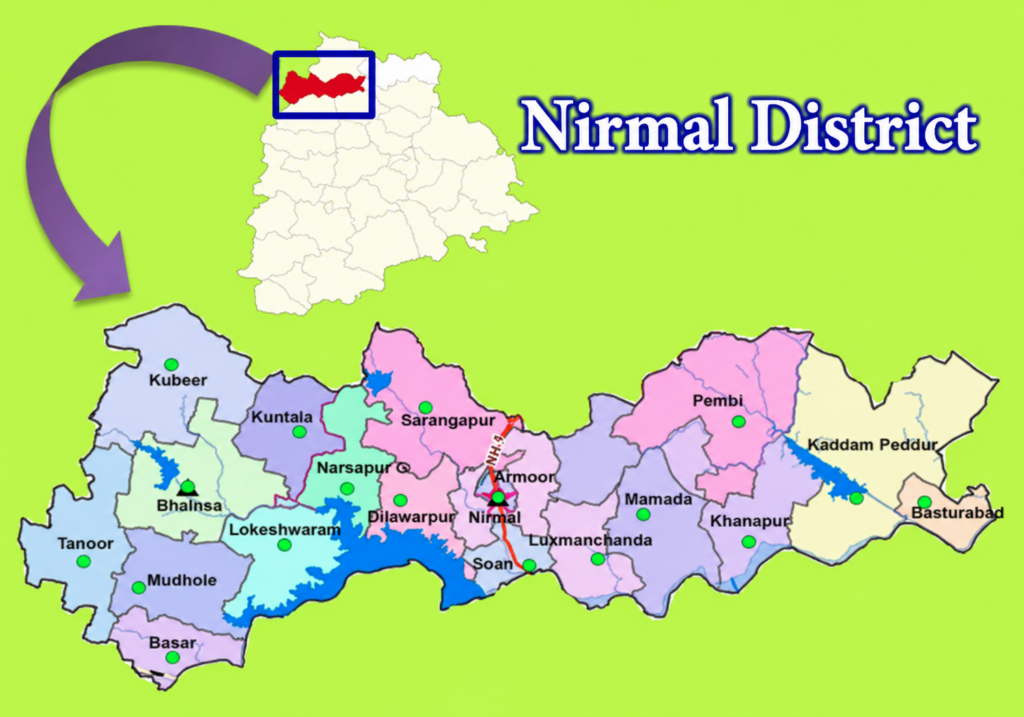
Nirmal District is home to three primary urban municipalities that serve as the region’s key administrative, commercial, and economic centers. These towns play a vital role in the district’s governance, infrastructure development, public services, and regional growth. Nirmal serves as the district headquarters and is the largest urban center, known for its administrative importance, cultural heritage, and thriving commercial activities. Bhainsa is a prominent commercial municipality and functions as the headquarters of the Bhainsa Revenue Division, acting as a major trade and business hub in the western part of the district. Khanapur serves as an important administrative municipality catering to the eastern region of the district and supports the surrounding rural communities through various government and civic services. In addition to these municipalities, Nirmal District is administratively organized into two revenue divisions—Nirmal and Bhainsa—comprising 19 mandals and approximately 400 Gram Panchayats that govern the district’s extensive rural network. Together, these urban centers and administrative units contribute significantly to the district’s development, connectivity, economic activity, and delivery of public services across both urban and rural areas.
Population of Nirmal District
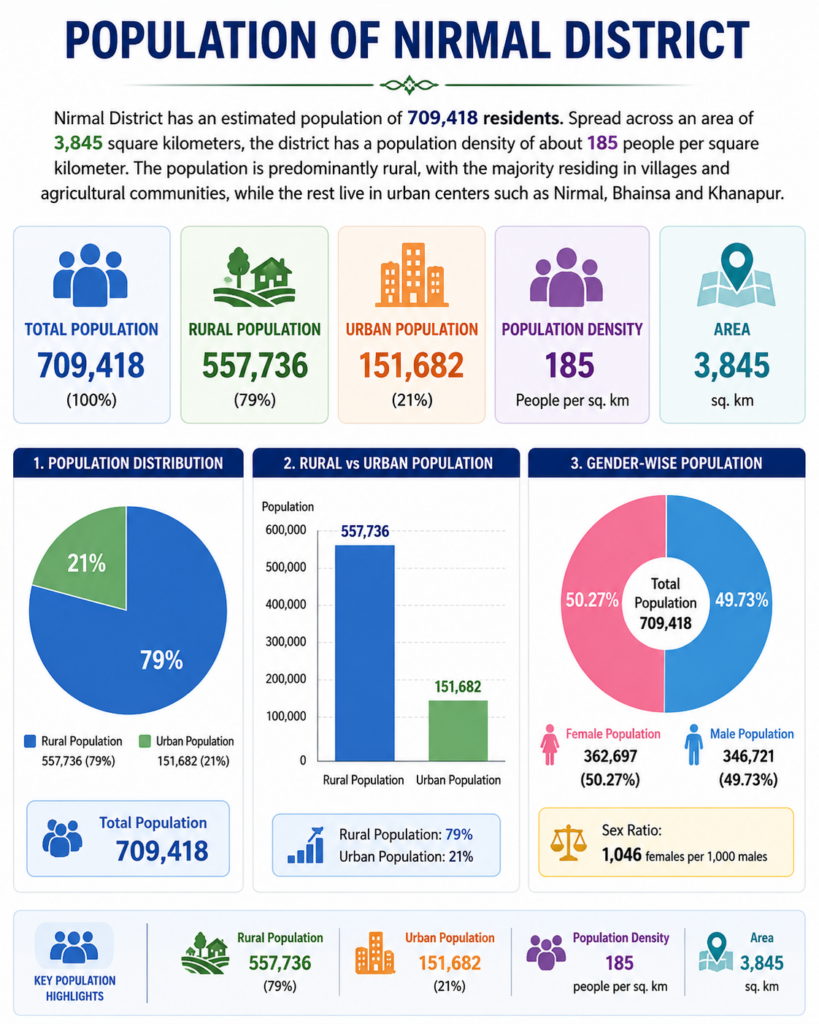
Nirmal District has an estimated population of 709,418 residents, making it one of the important districts in northern Telangana. Spread across an area of approximately 3,845 square kilometers, the district has a population density of about 185 people per square kilometer. The population is predominantly rural, with nearly four-fifths of the residents living in villages and agricultural communities, while the remaining population resides in urban centers such as Nirmal, Bhainsa, and Khanapur. This demographic distribution reflects the district’s strong agricultural foundation and rural character while also highlighting the growing role of urban centers in economic and social development.
Population Overview
| Population Indicator | Value |
|---|---|
| Total Population | 709,418 |
| Rural Population | 557,736 (79%) |
| Urban Population | 151,682 (21%) |
| Area | 3,845 sq. km |
| Population Density | 185 persons/sq. km |
Key Population Insights
- Total Population: 709,418 residents
- Rural Population: 557,736 residents (79%)
- Urban Population: 151,682 residents (21%)
- Area: 3,845 sq. km
- Population Density: 185 persons per sq. km
The population profile of Nirmal District highlights its predominantly rural nature, with agriculture and village-based livelihoods continuing to play a central role in the district’s social and economic structure.
Statistical Overview of Nirmal District
Nirmal District, situated in the northern part of Telangana, is a region characterized by a balanced blend of cultural heritage, agricultural prosperity, and demographic diversity. Spread across an area of approximately 3,845 square kilometers, the district is home to an estimated 709,418 residents living across 19 mandals and 428 villages. The district’s demographic profile reflects its predominantly rural nature, with agriculture serving as the backbone of the local economy. Nirmal is particularly notable for recording the highest female-to-male ratio in Telangana, highlighting a favorable gender balance compared to many other districts in the state. The district also showcases a diverse social composition, with Scheduled Castes and Scheduled Tribes accounting for a significant portion of the population. While the overall literacy rate stands at approximately 58%, urban centers such as Nirmal, Bhainsa, and Khanapur continue to drive educational and economic development. These statistics provide valuable insights into the district’s population structure, workforce participation, social composition, and developmental progress, making Nirmal an important administrative and cultural region within Telangana.
Key Statistics at a Glance
| Indicator | Value |
|---|---|
| Total Population | 709,418 |
| Area | 3,845 sq. km |
| Population Density | 185 persons/sq. km |
| Rural Population | 79% |
| Urban Population | 21% |
| Sex Ratio | 1,046 Females per 1,000 Males |
| Literacy Rate | 58% |
| Scheduled Castes (SC) | 15.24% |
| Scheduled Tribes (ST) | 11.36% |
Statistical Highlights
- Population exceeds 7 lakh residents.
- Nearly 79% of residents live in rural areas.
- 1,046 females per 1,000 males, the highest sex ratio in Telangana.
- Literacy rate stands at 58%.
- SC and ST communities together account for 26.6% of the population.
- Agriculture remains the primary economic activity, employing the majority of the workforce.
- The district combines strong agricultural foundations with growing urban development centered around Nirmal, Bhainsa, and Khanapur municipalities.
Population Distribution
Rural Population ████████████████████████████████████████ 79%
Urban Population ██████████ 21%
Gender Demographics
Females █████████████████████████ 50.27%
Males ████████████████████████▌ 49.73%
Sex Ratio: 1,046 Females per 1,000 Males
Literacy Rate
Literate Population █████████████████████████████ 58%
Non-Literate Population ██████████████████████ 42%
Social Composition
Scheduled Castes (SC) ████████ 15.24%
Scheduled Tribes (ST) ██████ 11.36%
Others ████████████████████████████████████ 73.40%
Religious Demographics
Hinduism ████████████████████████████████████████ 84.21%
Islam ███████ 14.04%
Others █ 1.75%
Employment Structure
Agricultural Labourers █████████████████████████ 49.3%
Cultivators █████████████████████ 41.6%
Household Industries ████ 9.1%
Geographical Area of Nirmal District
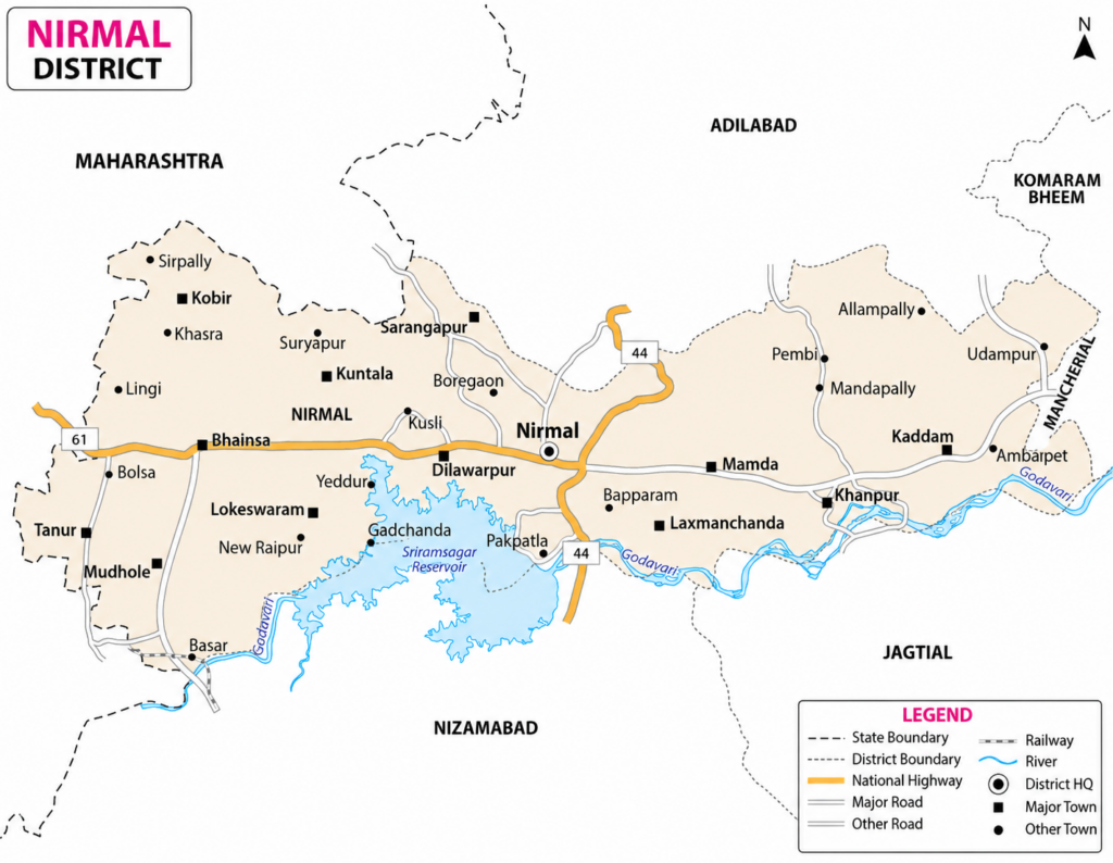
Nirmal District spans a total geographical area of 3,845 square kilometers (1,485 square miles), making it one of the significant districts in northern Telangana. Situated on the historic Deccan Plateau, the district is characterized by fertile agricultural lands, rolling terrain, forested regions, and the influential Godavari River basin. Administratively, Nirmal District is organized into two revenue divisions—Nirmal and Bhainsa—which oversee 19 mandals comprising 18 rural mandals and one urban administrative unit. The district encompasses 428 villages, forming an extensive network of rural settlements that contribute significantly to its agricultural and cultural identity. Strategically located, Nirmal shares its boundaries with Adilabad District to the north, Komaram Bheem District to the northeast, Mancherial District to the east, and Jagtial and Nizamabad districts to the south, with the Godavari River serving as a natural boundary in the southern region. To the west, the district borders Nanded District of Maharashtra, strengthening its regional connectivity and economic interactions. This favorable geographical location, combined with its well-structured administrative framework, plays a vital role in the district’s development, governance, agriculture, and transportation networks.
Geographic & Administrative Highlights
- Total Area: 3,845 sq. km (1,485 sq. mi), comprising fertile agricultural lands, forests, and rolling terrain across northern Telangana.
- Revenue Divisions: 2 – Nirmal and Bhainsa, ensuring efficient district administration and governance.
- Mandals: 19 (18 Rural + 1 Urban), supporting decentralized administration and local development.
- Villages: 428, forming a strong rural network that supports agriculture and traditional livelihoods.
- Geographical Region: Situated on the Deccan Plateau, known for its diverse terrain and natural resources.
- Southern Boundary: The Godavari River, providing irrigation, ecological value, and cultural significance.
- Neighboring Districts: Adilabad, Komaram Bheem Asifabad, Mancherial, Jagtial, Nizamabad, and Nanded (Maharashtra).
- Regional Importance: A strategically located district with a well-structured administrative system, contributing significantly to Telangana’s agriculture, culture, and regional development.
History and Heritage of Nirmal District
The Formation and Historical Identity of Nirmal
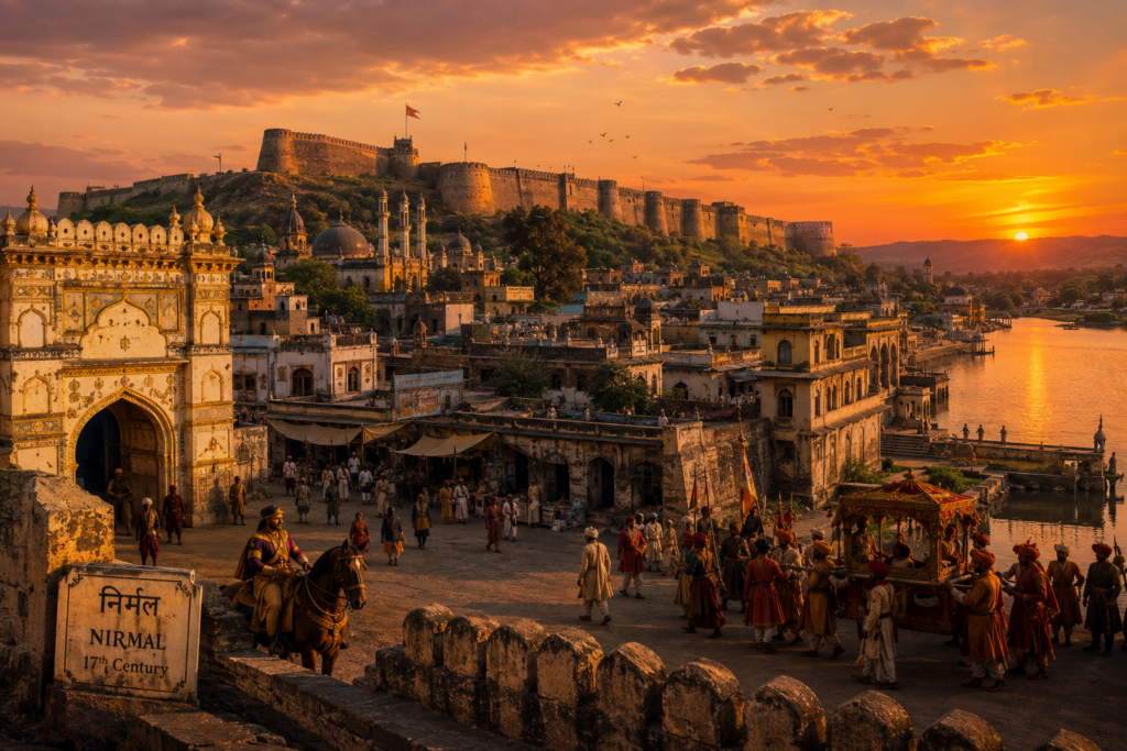
Nirmal District was officially formed on October 11, 2016, after being carved out of the erstwhile Adilabad District during the administrative reorganization of Telangana aimed at improving governance and public service delivery. Located in the northern part of the state, the district shares its borders with Maharashtra and the Telangana districts of Adilabad, Komaram Bheem Asifabad, Mancherial, Jagtial, and Nizamabad, making it an important regional gateway. The name “Nirmal” is widely believed to have originated from Nimma Naidu (Nimma Rayudu), a 17th-century local chieftain and renowned patron of arts who played a pivotal role in the region’s cultural and administrative development. Under his leadership, Nirmal flourished as an important administrative center and gained recognition for its thriving artistic traditions, laying the foundation for the district’s enduring legacy as a center of craftsmanship and cultural heritage.
The Artistic Legacy of Nirmal
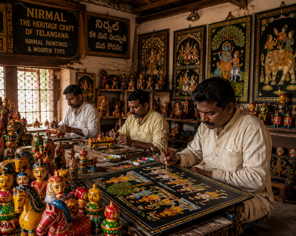
Nirmal gained international recognition for its exceptional arts and handicrafts, a tradition that dates back more than 400 years. According to historical accounts, Nimma Naidu (Nimma Rayudu) invited skilled Naqqash artisans to settle in the region, laying the foundation for Nirmal’s flourishing handicraft industry. These artisans perfected the renowned Nirmal Paintings, distinguished by their elegant black backgrounds, intricate detailing, and the use of natural colors inspired by Mughal and Deccan artistic styles. They also introduced the iconic Nirmal Wooden Toys, handcrafted from lightweight Tella Poniki wood and celebrated for their vibrant colors and fine craftsmanship. Over the centuries, these traditional art forms became enduring symbols of Telangana’s rich cultural heritage, earning prestigious Geographical Indication (GI) tags that recognize their authenticity and unique craftsmanship. Today, Nirmal continues to preserve this centuries-old artistic legacy and is widely regarded as one of India’s most prominent centers for traditional handicrafts and decorative arts.
Forts, Spiritual Importance, and Educational Significance
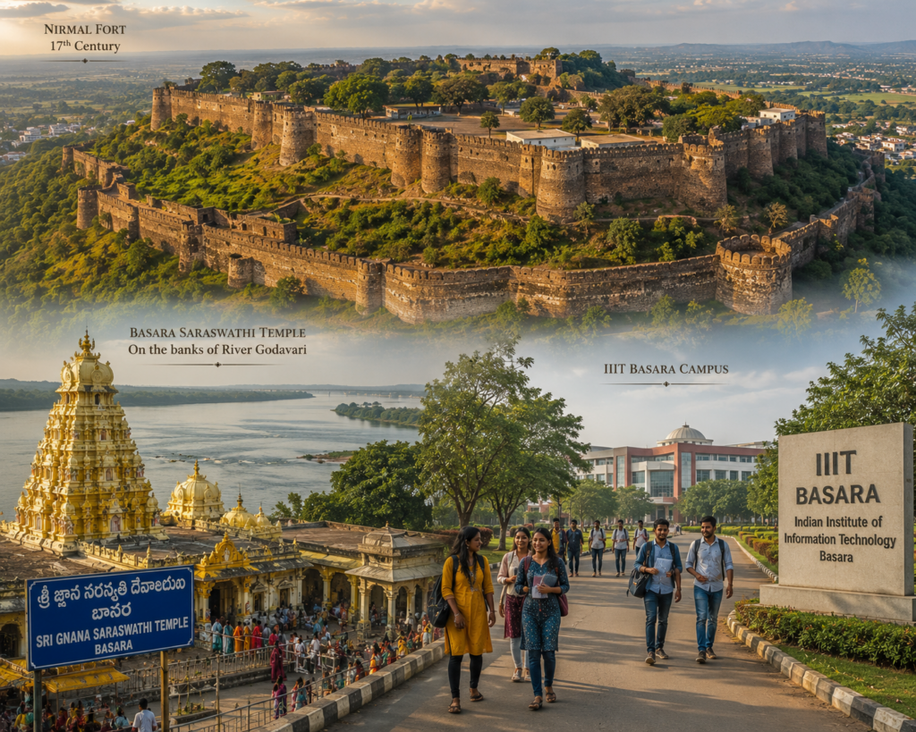
Historically, Nirmal occupied a strategically significant position in the Deccan and was frequently contested by the Mughals, Marathas, and the Golconda Sultanate during the 17th and 18th centuries. Owing to its formidable fortifications, defensive walls, watchtowers, underground escape passages, and an interconnected network of historic chain tanks designed for water conservation and security, the town came to be known as “Bathishgadh” (the Fort of Thirty-Two Bastions). Beyond its military significance, Nirmal has long been a center of spirituality and learning. The district is home to the revered Sri Gnana Saraswathi Temple at Basar, one of the few temples in India dedicated to Goddess Saraswathi, where thousands of devotees visit annually to perform the sacred Akshara Abhyasam ceremony for children. In recent decades, the establishment of the International Institute of Information Technology (IIIT) Basara has further enhanced the district’s reputation, transforming it into a prominent educational hub and contributing to its socio-economic development in Telangana.